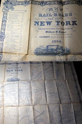
1864 Map of the Rail-Roads of the State of New York Prepared Under the Direction of William B. Taylor By S.H.Sweet, Deputy State Eng.r And Suv.r
Albany New York: Weed, Parsons & Company, 1864. Folding map printed in blue tones on thin paper; approx. 25" x 30 1/2" size; with a decorative border and inset of a steam locomotive in full throttle traveling cross-country; also with inset list of 'Rail Roads in Operation" with various lengths of roads; map gives rail lines, indications of bituminous coal findings, canals, city, town, county designations; one part of the border line partially chipped away, old holing along fold lines, no loss, closed tear along one panel; some light foxing, spotting, unobtrusive; no covers; the map in good condition, a nice survival and decorative, of the railroads to be found in New York State during the Civil War period. Item #20612
Price: $250.00