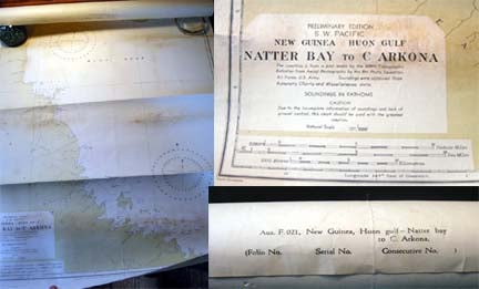
1943 Chart Preliminary Edition S.W. Pacific New Guinea Huon Gulf Natter Bay to C. Arkona Aus. F.021
Australia: Hydrographic Branch, Dept. Of the Navy, 1943. Chart, tinted in color; approx. 28" x 40" size; a few penciled triangulation routes & distances noted, a couple of pen notations, indicating Tambu bay and some distances around Lasanga I.; the Australian Navy Dept. published this chart of the coastline of New Guinea "...from a plot made by the 648th topographic Battalion from Aerial Photography by the 8th Photo Squadron, Air Force, U.S. Army. Soundings were obtained from Admiralty Charts and Miscellaneous data...should be used with the greatest caution."; the words "Small Corrections" printed at bottom left; with some staining and wear, old lines from being rolled for 60+ years; good condition overall, an interesting artifact from the Pacific theater of World War II; printed on heavy stock, hence this good survival; may have actually seen some military service in this theater of war. Item #20037
Price: $45.00