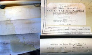
1943 Chart Preliminary Edition S.W. Pacific New Guinea Huon Gulf Natter Bay to C. Arkona Aus. F.021
Australia: Hydrographic Branch, Dept. Of the Navy, 1943. Chart, tinted in color; approx. 28" x 40" size; a few penciled triangulation routes & distances noted, a couple of pen notations, indicating Tambu bay and some distances around Lasanga I.; the Australian Navy Dept. published this chart of the coastline of.....